(1) INTRODUCTION
Welcome to our public consultation event and thank you for taking the time to view these proposals online. The information provided sets out a general overview of the proposed redevelopment in advance of progressing detailed design work and covers the following areas:
- Introduction
- Site and redevelopment overview
- Reasons for dairy farm closure in Summer 2021
- Consultation and engagement to date
- Existing site
- Early site assessments
- Opportunities and constraints
- Development proposals – Concept Site Plan
- Development proposals – Materials and Heights
- Summary, Feedback and Next Steps
Should you have any questions please do not hesitate to contact James Gaiger (james@gaigerbros.co.uk) or Nick Church (nick@gaigerbros.co.uk) via email or by telephone on 01380 722412.
This information will be available online at https://gaigerbros.co.uk/townsend-farm-poulshot-consultation from Friday 8th July until Friday 22nd July 2022.
A feedback form is available, and we would welcome your views by completing and returning the form by email (nick@gaigerbros.co.uk) or post (FAO Nick Church, Gaiger Bros Ltd, Kennet House, Northgate Street, Devizes SN10 1JT). All responses to be returned by close of business Friday 22nd July 2022.
(2) Site AND REDEVELOPMENT overview
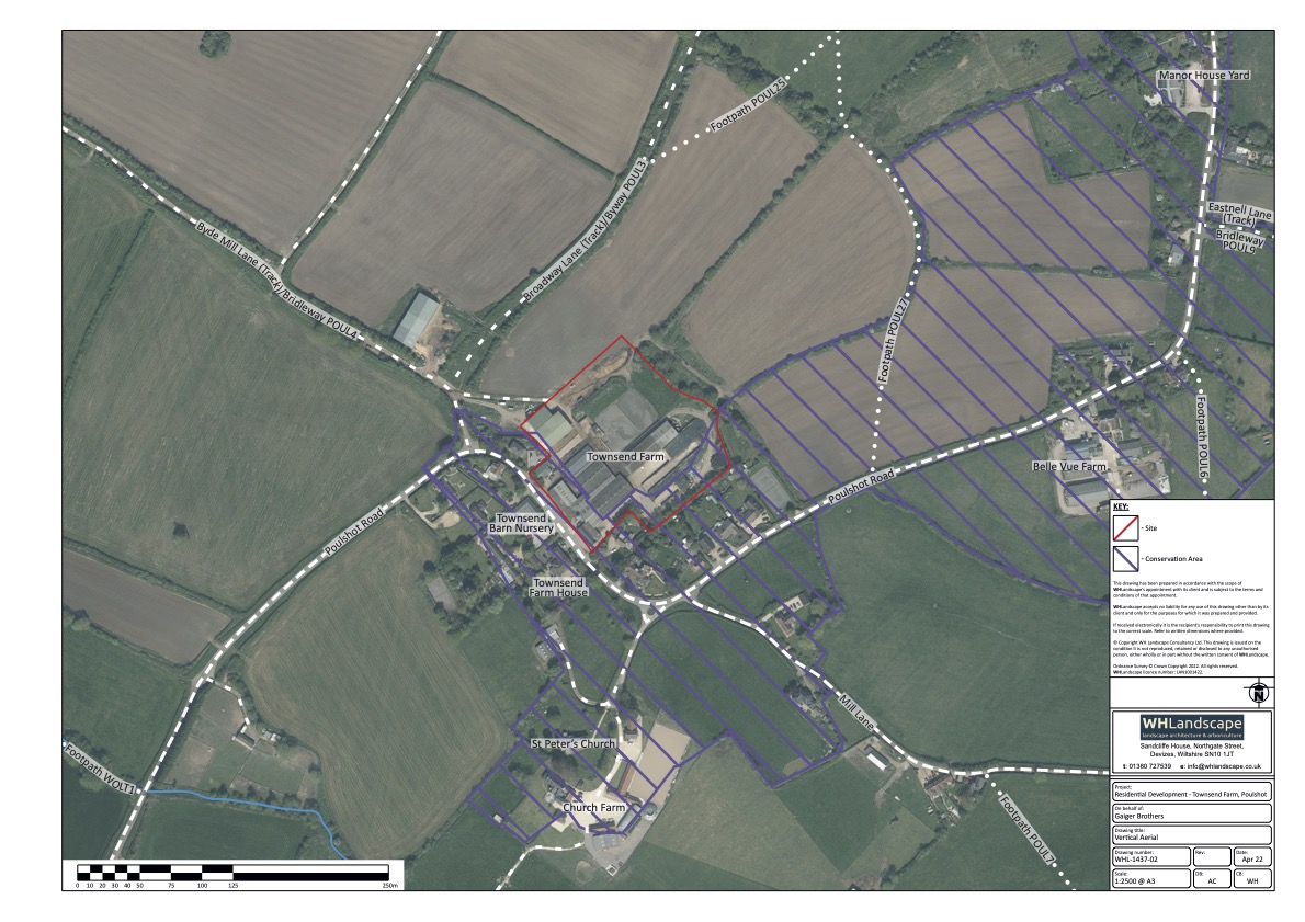
Townsend Farm yard is located at the southern end of Poulshot, with the southern and western edges of the site falling within the Poulshot Conservation Area. The farmyard covers an area of approximately 4.1 acres (1.67 ha) and sits within a wider land area of approximately 240 acres extending to the west.
Gaiger Brothers have an agreement with the Landowner to identify a redevelopment proposal and prepare a detailed planning application to secure planning consent for any proposed change of land use. We consider that there is scope for approximately 15 houses at the site, although this remains subject to ongoing review, informed by the feedback from this stage of public consultation and wider technical and design work. Alternative uses at the site have been considered, however other livestock-based farming activities would have similar constraints and re-purposing the buildings to commercial/storage uses is unlikely to be appropriate at this location.
Subject to the outcomes of this stage of public consultation and community engagement, the current intention is to prepare a detailed planning application for submission to Wiltshire Council before the end of 2022.
(3) reasons for Dairy Farm CLOSURE in Summer 2021
The White Family have owned Townsend Farm for many years but ceased operating a dairy in the summer of 2021 due to several factors including:
- Existing building/infrastructure constraints including insufficient slurry storage, poorly ventilated buildings and future regulation changes, heightening these constraints and requiring substantial capital investment to address.
- Being located close to existing residential properties adds challenges to meeting planning policy requirements associated with any future improvements, and significantly adds to both planning risks and capital investment required.
- Layout of the yard at the far end of the land holding (which extends to the west), limiting scope for a more grazing based dairy unit and the site being located within a high-risk bovine tuberculosis area also making this unfeasible.
A significant investment would be required to address these constraints, and this is unlikely to yield a guaranteed return given the fluctuating dairy market. Coupled with prolonged past bovine tuberculosis problems experienced over the past c20 years, this has resulted in the closure of the dairy farm at Townsend Farm.
There remain interim uses ongoing at the site, these include: a small herd of pigs in one of the barn buildings, limited storage within existing buildings and a workshop. The wider land holding remains in agricultural use.
(4) CONSULTATION AND ENGAGEMENT TO DATE
We contacted Poulshot Parish Council in February 2022 and held an introductory site walkover meeting with representatives of the Parish Council in early March 2022. We have maintained regular communication with the Parish Council including a further meeting in April 2022, also attended by Tamara Reay, the Wiltshire Councillor for Devizes Rural West.
We also contacted the immediate neighbours to the site in March 2022 given their proximity to any proposed redevelopment. This was well received, and we have subsequently met many of those neighbours. This has identified a broad range of issues and opportunities including the scale, type and building heights of any redevelopment, and drainage and flood risk concerns as the key areas of interest. Additional topics raised included access and highway impacts; boundary treatments to adjacent neighbours; contamination including the slurry lagoon; impacts on ecology; construction impacts; and a range of design considerations including the general architectural approach, energy efficiency and lighting impacts. It was also recognised that an appropriately scaled and designed housing redevelopment would address noise, smell, flies, and other issues associated with the previous dairy farm operation.
Several site assessments have now been completed and before undertaking detailed design work, the purpose of this wider public engagement is to share the findings of our initial engagement and site assessment work with the local community, alongside our early thoughts on the broad principles of the redevelopment opportunity, and to listen to your views and feedback.

(5) Existing Site
- Approximately 4.1 acres (1.67ha)
- Contains a range of agricultural buildings as well as extensive areas of hardstanding and former slurry lagoon / silage clamps
- Two points of access onto Poulshot Road frontage
- Residential properties and Townsend Barn Nursery opposite the southern site boundary and residential neighbours to eastern/south-western boundaries
- Dairy closed in 2021, whilst ongoing uses include a small herd of pigs in one of the barn buildings, limited storage and a workshop
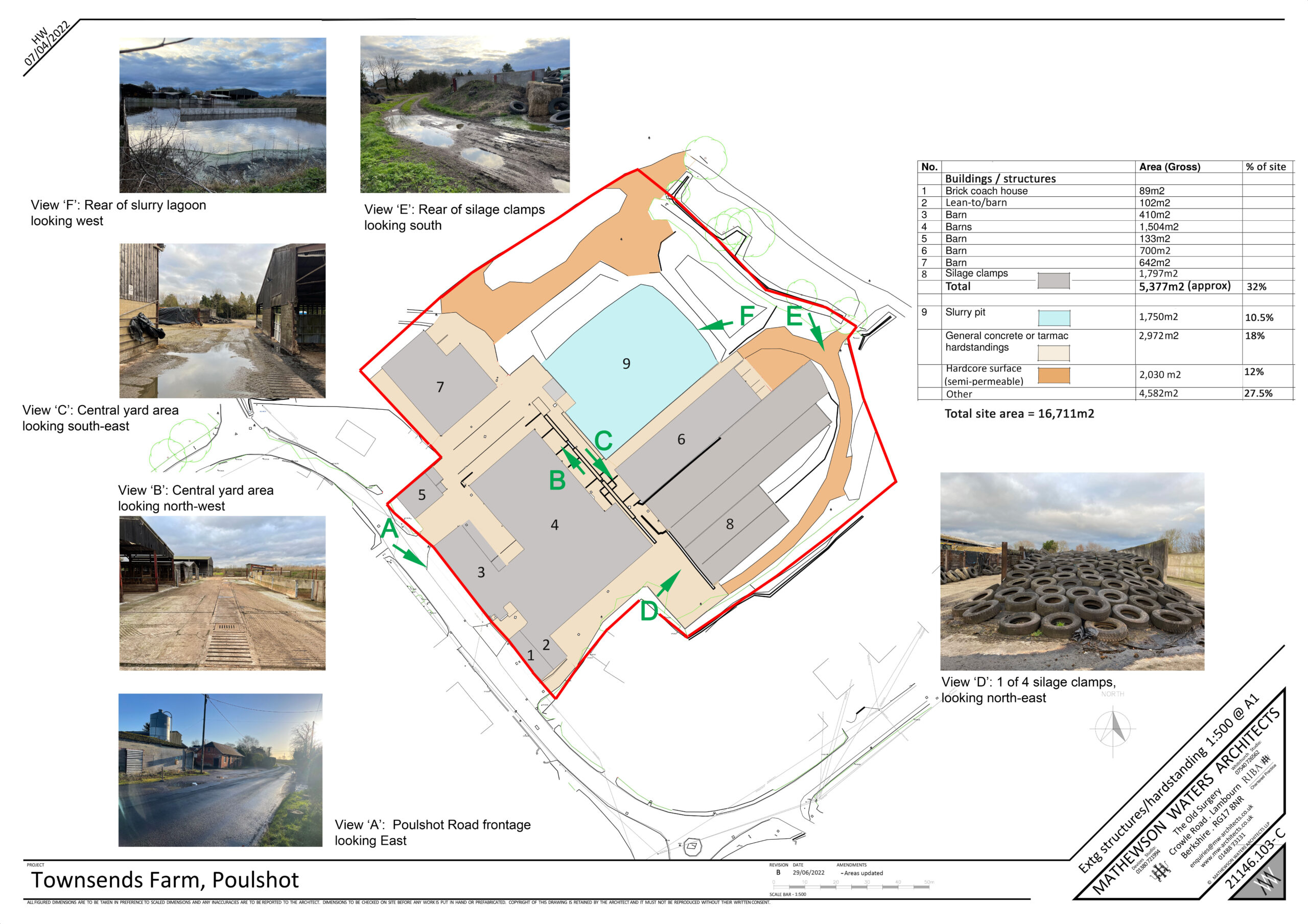
(6) Early site assessments
In planning policy terms, Poulshot is designated within the Wiltshire Council Core Strategy (current adopted Local Plan) as a ‘Small’ village and accordingly would typically only be expected to accommodate small scale infill development. This proposal at Townsend Farm would not conform with that broad policy direction, however, there remains a need to assess the site as a former farmyard and how best to reuse the site.
Several site surveys and assessments have been undertaken including into flood risk & drainage, access & highways, ground conditions & contamination, heritage, ecology and landscape issues. These have focussed on identifying site constraints and opportunities that the redevelopment proposal will need to respond to. Whilst the full details of these assessments will be incorporated into reports to be submitted with any future planning application submission, these assessments have all informed the design process and a summary of the key findings related to flood risk and drainage is set out below.
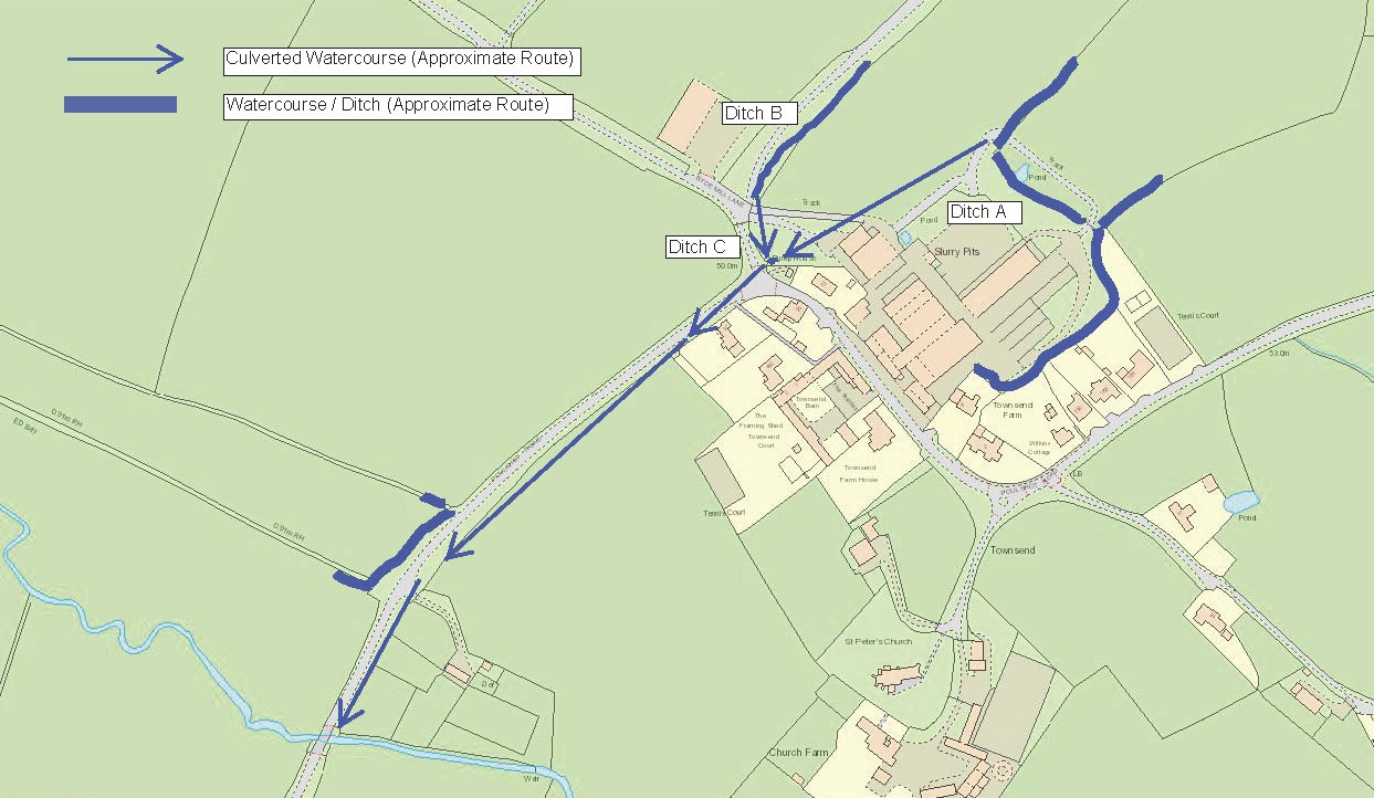
Flood risk and drainage concerns were identified by the immediate neighbours to the site as being a key concern given historic surface water flooding and foul drainage issues in the local area. There are controls and requirements through the planning system to demonstrate thorough consideration is given to flood risk and drainage issues:
- Developers need to demonstrate development can be delivered safe from the risk of flooding (including allowance for future climate change) and most importantly without impacting on the flood risk of existing neighbouring properties. A Flood Risk Assessment report including a Surface Water Drainage Strategy showing how the site is drained will be prepared as part of any planning submission to demonstrate this and will be subject to Wiltshire Council review and approval in their role as the Lead Local Flood Authority (LLFA).
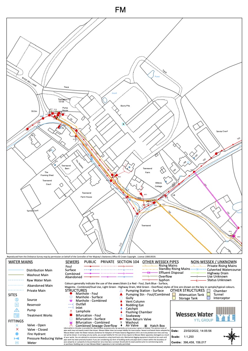
- Wessex Water are responsible for providing foul water drainage and potable (fresh) water supply to existing and new development in the local area
Given the importance of these issues, an initial drainage assessment has been completed which included the following tasks:
- Site visits undertaken
- Clearance of on and off-site drainage ditches
- Topographical survey of site & Poulshot Road frontage
- Review of publicly available flood records
- Wessex Water asset records obtained
- Wiltshire Council highway drainage records obtained
- Infiltration testing completed
- Consultation with Wessex Water regarding foul water connection & capacity checks
Through this work, the following findings have been confirmed:
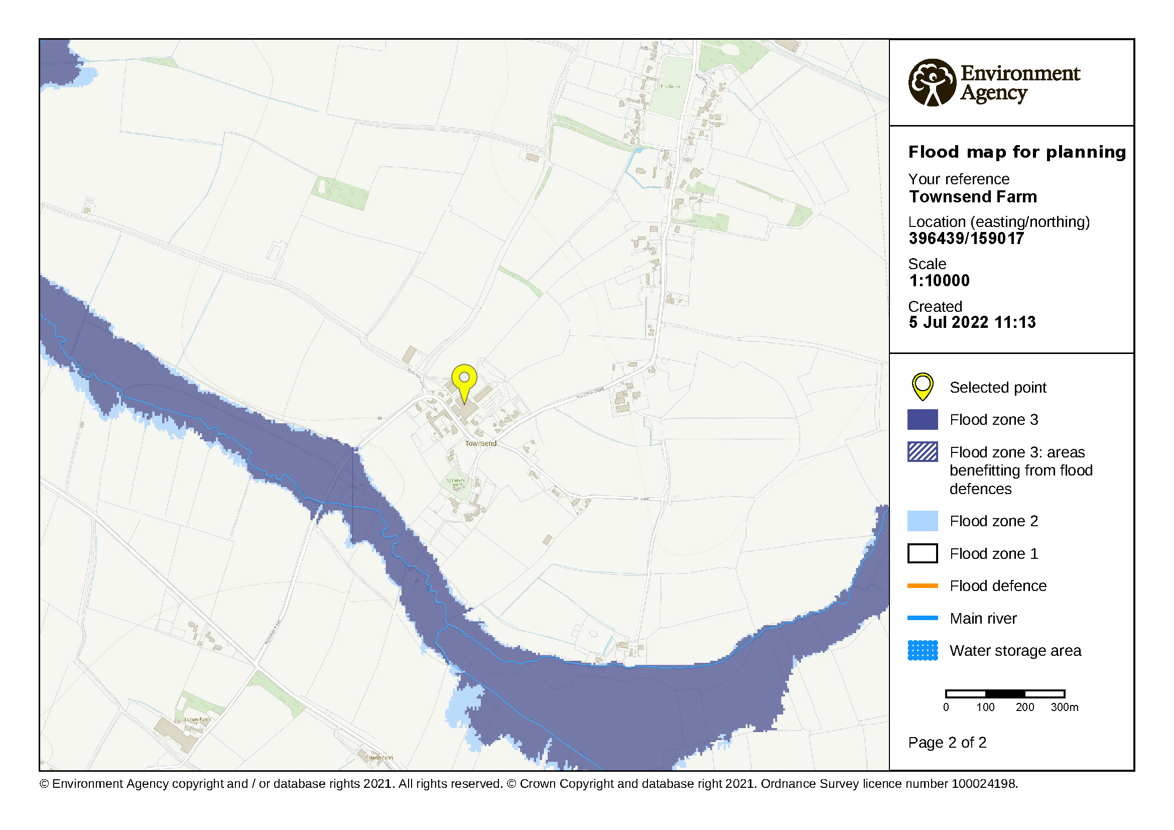
Flooding from watercourses
- The site falls within Flood Zone 1 of the Environment Agency’s Flood Map for Planning, which has a low probability of flooding from watercourses.
- Areas designated as flood risk zones (flooding and extreme flooding) are located c240m to the southwest of site along a tributary to Summerham Brook
Outcome: the site is located in Flood Zone 1, not at risk of flooding from a watercourse and this will be detailed within a Flood Risk Assessment to be submitted with any planning application.
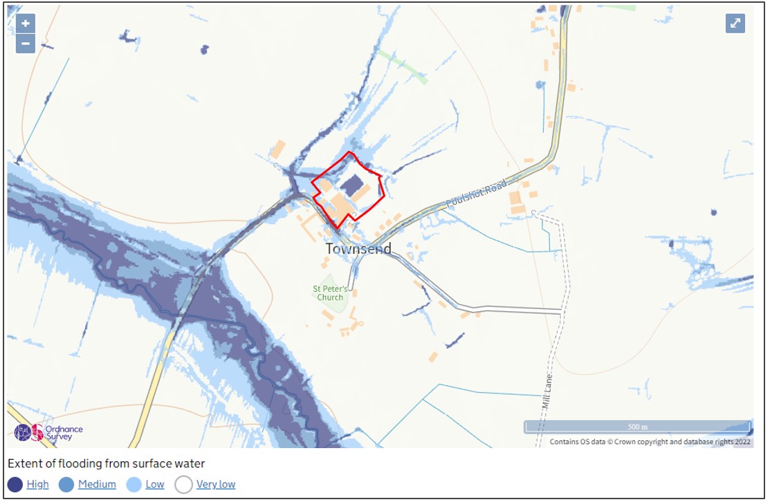
Surface water flood risk
- The Environment Agency’s Risk of Flooding from Surface Water Map indicates where surface water may be expected to flood or pond when rainwater does not drain away through normal drainage system or soak into the ground, but lies on or flows over the ground instead
- The site is predominantly classified as an area with a ‘very low’ or ‘low’ risk of surface water flooding.
- ‘Very low’ risk means that each year the area has a less than 0.1% chance of flooding; ‘low’ risk is defined as between 0.1% and 1% chance of flooding
- Smaller isolated areas of elevated risk within the site are associated with low points where surface water runoff could collect. These areas of ‘medium’ and ‘high’ risk align with the slurry lagoon, the existing drainage ditches and lower lying ground at the western part of the site.
- ‘Medium’ risk is defined as 1% – 3.3% chance of flooding; ‘high’ risk is defined as greater than 3.3% chance of flooding
- Poulshot Road is identified as an area of ‘high’ risk extending to the south toward where it crosses the tributary to Summerham Brook
Redevelopment opportunities:
- Any redevelopment would result in a substantial (c50%) reduction in hardstanding across the site, significantly reducing existing runoff rates and volumes.
- The redevelopment will introduce a Sustainable Drainage System (SuDS) designed and constructed to current standards. Rainfall falling on the site will therefore be intercepted and managed by a drainage system including a ‘balancing pond’ sized to provide attenuation storage for the site, taking into account the requirement to design for +45% climate change and future urban creep (i.e. potential building extensions and/or additional paved areas).
- The drainage ditch to the east of the site and adjacent to neighbouring properties will remain unaffected by the development.
- Thresholds of properties should be raised 300mm above existing ground levels to prevent the ingress of surface water (as is good practice).
Outcome: the redevelopment proposal will manage constraints by avoiding areas of higher flood risk, introducing a Sustainable Drainage System (SuDS) designed to current standards & substantially reducing the impermeable area on the site compared to the existing site (see #8 ‘Development proposals – Concept Site Plan), providing betterment by significantly reducing runoff rates and volumes and surface water flood risk.
Foul water
Following concerns raised by immediate neighbours regarding historic foul sewer issues and questioning if there is adequate capacity to accommodate flows generated by the proposed redevelopment, we have written to Wessex Water who have confirmed:
- “In 2003 we laid a duplicate sewer in Poulshot Road to reduce the risk of sewer flooding in the area. In 2006 a new rising main was laid from Poulshot Townsend SPS to replace the existing rising main which had come to the end of its asset life and was suffering repeated bursts.”
- A recent CCTV survey undertaken in 2022 “showed that the sewer was in both a satisfactory structural and serviceable condition and no remedial works are required”. Also confirming that “We routinely maintain three non-return valves and a bifurcation on the gravity sewer network along with the sewage pumping station and an air valve on the rising main in this area”
- “We have capacity within the public foul network and at the Treatment Works to accept the proposed domestic type foul flows from 15 dwellings. A connection to the 150mm or 225mm diameter public foul sewer on Poulshot Road would be acceptable”.
Outcome: Wessex Water has confirmed a future point of connection(s) to existing foul sewers in Poulshot Road, and that there is adequate capacity in the existing sewers, Townsend Foul Water Pumping Station, and at Potterne Sewage Treatment Works for a redevelopment of 15 dwellings.
Other key findings and recommendations from site assessments
Access & Highways
- A single point of access designed to current highway standards is proposed allowing for the consolidation of vehicle movements to/from the site.
- There are opportunities to improve pedestrian access into the village centre to the north-west via Broadway and to the north-east by extending the existing footway on Poulshot Road to link Townsend and Mill Lane.
- 14 houses would result in a modest increase in total daily vehicle trips, and a reduction in HGV trips.
- There are opportunities to access local facilities and services in the village on foot or bike, and a limited bus service offering 2-3 services per day to locations including Devizes, Worton and Trowbridge, with unmarked local bus stops located on Poulshot Road approximately 200m from the site.
Contamination
- A desk-top ground condition and contamination assessment has been undertaken, confirming the potential presence of contaminants and below-ground obstructions and disturbance to be present, as would be expected of a former farm yard.
- Further ground investigation of the site will be undertaken, likely to include an intrusive soil investigation, gas and groundwater monitoring to assess any potential for ground gas and vapour risk, particularly in the vicinity of the slurry lagoon / silage clamps.
- A geotechnical appraisal is also proposed in order to assess ground instability and below ground features / obstructions, determine the nature and extent of any Made Ground beneath the site, confirm the natural geological profile below the site and inform foundation design criteria.
Heritage
- It will be important to ensure that access arrangements are as low-key as possible. Surface treatment needs to be sympathetic to the rural location to maintain a semi-formal appearance, and kerb lines, boundary features, and external lighting should be kept to a minimum. Low intensity and low-level lighting should be investigated. The overall density and heights of any new buildings should also be low. Soft landscaping could also help alleviate the existing transition between built form and the open fields to the north-west.
- If carefully managed, the re-purposing of this previously developed land is likely to be positive and beneficial. The character of the Conservation Area stands to be enhanced, and the north-side setting of Townsend Farmhouse improved.
Ecology
- The majority of the land within the development site is concrete and buildings, with small fringing areas of grass/ruderal vegetation and boundary habitats comprising trees/shrubs and a small, ephemeral field drainage ditch. There are no notable or invasive habitats or plants within the development site.
- None of the buildings or structures within the development site are being used by bats for roosting or as a place of rest, and they all provide no/negligible future opportunities for roosting bats given the physical and environmental conditions of the buildings.
- There is no confirmed evidence that protected/notable mammals use the development site but given the semi-rural (residential and farmland) setting there is potential for animals to use or traverse the site, particularly hedgehog.
- There is some evidence of common bird nesting within some buildings, while it is also recognised that nesting birds could potentially use additional buildings or larger trees/shrubs in the future. The site does not support nesting barn owl or ground nesting birds.
- Measures to reduce development impacts and deliver betterment are likely to include: protecting animals and nesting birds during construction; sensitive design of any external lighting; provision of bat roosting bricks and bird nesting boxes; a comprehensive site landscaping strategy with associated tree/shrub/hedge planting; maximising ecological benefits of any surface water drainage features, and other features that could be incorporated into the future site landscaping.
(7) Opportunities and constraints
The redevelopment proposal is being shaped by several design considerations (see plan with annotations) and the following overarching key design objectives:
- Contain development within the broad existing building & structures footprint
- Respect the privacy of neighbouring properties
- Remediate and naturalise the site and provide a robust drainage and landscape strategy
- Deliver a scale and form of development responding to the Conservation Area status & general locality whilst generating sufficient value to cover associated site demolition, remediation and wider development costs

(8) Development proposals – Concept Site Plan
We anticipated from the start of the site assessment and design process that there might be scope for approximately 15 houses at the site.
We have now completed baseline site assessments along with early engagement with the immediate site neighbours and have prepared our proposed layout responding to the identified site opportunities and constraints and our key design objectives.
This layout provides 14 houses including:
- 10 open market houses and 4 affordable houses, complying with the Wiltshire Council policy requirements for 30% provision
- A mix of 2/3 bed affordable houses, and 3-5 bed market houses
Other key features of the development proposal include:
- A significant reduction in buildings and hardstanding (see inset plan)
- A balancing pond required as part of the surface water drainage strategy, and potentially set within a wider naturalised area for use as a wildflower meadow, woodland or pony paddock (subject to the completion of further technical assessments).
- Improved pedestrian connections through a new connection in the north-western corner to Byde Mill Lane and onward toward the village via Broadway, and a new footway on Poulshot Road connecting existing provision at Townsend through to Mill Lane.
The final number and mix of houses (and tenure of the affordable housing) remain subject to feedback from this consultation and wider engagement and will also be informed by the findings of the Rural Housing Needs Survey due to be undertaken by Wiltshire Council and Poulshot Parish Council.

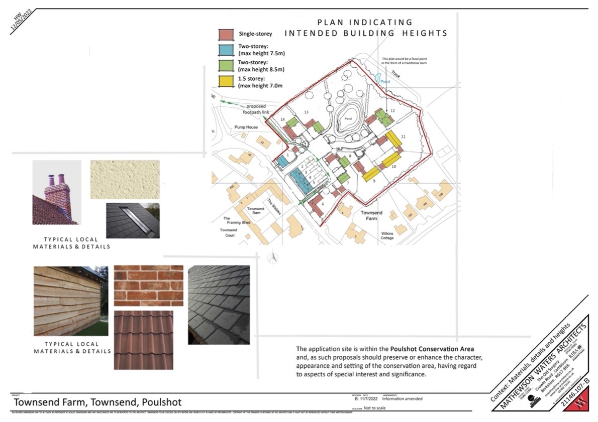
(9) Development Proposals – Materials, Details and Heights
We remain at an early stage of the design process and this consultation is seeking your views on the key design principles influencing the site layout including: the number of houses, their location within the site, mix of market and affordable housing types, house sizes (number of bedrooms) and proposed building heights.
We have summarised within this plan the proposed building heights for your review, alongside some images showing local examples of building materials that we anticipate will influence and/or be incorporated into detailed building designs influenced by existing cottages in the village.
Following your feedback, we will review and finalise the Concept Site Plan before undertaking detailed design work looking at building elevations, floorplans and materials.
We propose that each house will benefit from low carbon and renewable energy supply and will be resilient to future climate change with features likely to include:
- Air source heat pumps to provide heat into buildings
- Provide electric vehicle charging at each property
- Embed materials and waste management measures into the construction and operational phases of the development
- Landscaped and planted SuDS features to create an attractive feature within the development, and incorporating permanent water to enhance biodiversity and amenity value
(10) Summary, Feedback and Next Steps
Thank you for taking the time to attend and/or view these proposals online, which we hope has:
- Explained the reasoning behind the redevelopment proposal due to the closure of the dairy at Townsend Farm.
- Summarised the consultation and engagement undertaken to date.
- Described the existing site containing a range of agricultural buildings as well as extensive areas of hardstanding and former slurry lagoon / silage clamps.
- Summarised the findings from site assessment work with significant emphasis provided to flood risk and drainage concerns raised during meetings with the immediate site neighbours and demonstrating that:
- The redevelopment proposal will manage constraints by avoiding areas of higher flood risk, introducing a Sustainable Drainage System (SuDS) designed to current standards & substantially reducing the impermeable area on the site compared to the existing, providing betterment by significantly reducing runoff rates and volumes and surface water flood risk.
- Wessex Water has confirmed a future point of connection(s) to existing foul sewers in Poulshot Road, and that there is adequate capacity in the existing sewers, Townsend Foul Water Pumping Station, and at Potterne Sewage Treatment Works for a redevelopment of 15 dwellings.
- Outlined the key site opportunities and constraints and identified design objectives which have shaped the redevelopment proposal.
- Presented our redevelopment proposal for 14 houses, including:
- 10 open market houses and 4 affordable houses, complying with the Wiltshire Council policy requirements for 30% provision.
- A mix of 2/3 bed affordable houses, and 3-5 bed market houses.
- Summarised within this plan the proposed building heights for your review, alongside some photos and images showing local examples of building design, materials, and details that we anticipate will influence and/or be incorporated into detailed building designs
The final number, mix of houses and the wider site layout remains subject to review following feedback from this consultation and wider engagement.
We hope you have found the information provided helpful as you assess our proposals and that we have been able to respond to any questions you have. A copy of the consultation information will be available online at https://gaigerbros.co.uk/townsend-farm-poulshot-consultation from Friday 8th July 2022.
A feedback form is available, and we would welcome your views by completing and returning the form at our event. If you are unable to attend in person and/or would like more time to consider your response, you can alternatively submit your feedback by email (nick@gaigerbros.co.uk) or post (FAO Nick Church, Gaiger Bros Ltd, Kennet House, Northgate Street, Devizes SN10 1JT). All responses to be returned by close of business Friday 22nd July 2022.
Click on one of the links below to complete the form and send please back to us as per the above instructions:
We have outlined an indicative planning submission programme identifying the key activities going forward. Subject to the outcomes of this stage of public consultation and community engagement, the current intention is to prepare a detailed planning application for submission to Wiltshire Council before the end of 2022. It is difficult to predict the amount of time it could take to determine a planning application of this nature, but we would hope that could be completed within 6-9 months and estimate that the earliest start for any site demolition and construction would take a further 3-6 months, subject to securing planning approval. It is anticipated it could take approximately 18 months to complete the construction stage.
